Skyway is a drone ‘superhighway’ built using Altitude Angel’s ARROW technology.
Skyway creates ‘Separation-as-a-Service’ to revolutionise drone operations, making Beyond Visual Line Of Sight (BVLOS) operations routine, and scalable automated flight a reality. This is achieved through a simple software integration with the drone operator, eliminating the need for specific drone equipment.
Skyway is compatible with all legal drone types, allowing for an integrated airspace without imposing changes on other users. It operates on an "opt-in" model, allowing users to share airspace seamlessly. In essence, Skyway unlocks the 'Holy Grail' of drone capabilities with a user-friendly and inclusive approach.
Skyway's different approach
Unlike other approaches, Skyway does not believe segregating, closing airspace or the use of mandatory transponders is the scalable way forward to BVLOS drone operations. Traditional methods like Temporary Danger Areas (TDAs), Temporary Reserve Areas (TRAs), and Transponder Mandatory Zones (TMZs), while solving distinct problems, still introduce a form of segregation. Skyway, removes the need for any of the above for users operating within an Skyway superhighway or zone. Additionally, the information within the Skyway system can be mapped onto existing aviation charts.

Safety at its core
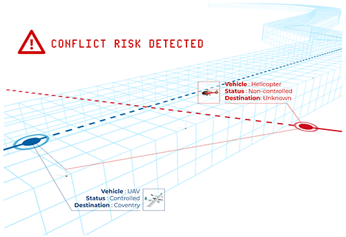
Skyway stands out for its superior safety measures. Using Altitude Angel's ARROW multi-sensor layered approach and a network-wide surveillance view Skyway processes and fuses data from various sensors to create the best operating picture. Unlike other options, it does not rely on air traffic using transponders; instead, it actively detects non-conformant air traffic and general aviation, mitigating the risk of collisions. Additionally, Skyway eliminates the need for Transponder Mandatory Zones and Temporary Danger Areas. Removal of these zones allows other air users to operate in an area where drone operations are conducted safely.