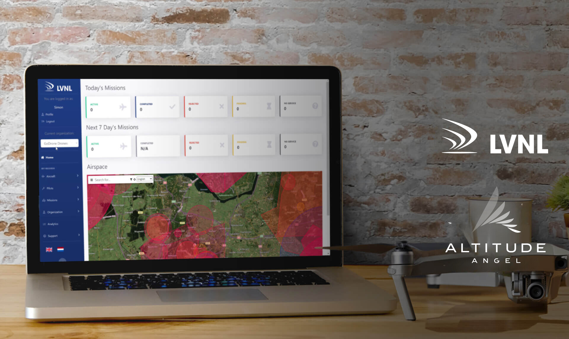
 GoDrone Operator Portal showing upcoming and planned drone missions
London, UK: Air Traffic Control the Netherlands (LVNL) has today introduced two significant upgrades for drone operators. These upgrades include creating an account in the (web)app and the ability for certified drone operators to submit an application, and receive permission, to fly in controlled airspace (CTR) via the Altitude Angel powered GoDrone app and website.
With the new feature, LVNL is making the process for this kind of applications, which until now was conducted via telephone or e-mail, quicker and more efficient.
“We’re excited by this upgrade in the GoDrone app and web portal,” says Jurgen van Avermaete, General Manager Procedures at LVNL. “Certified drone pilots and organisations can register and create an account for free and in doing so are able to submit preliminary applications for drone flights in controlled airspace in the Netherlands. It is an important step in safely integrating drones in Dutch airspace.”
By creating an account, the user gains access to the GoDrone Operator Portal. This portal is a pre-flight planning tool which provides information about the airspace and obstacles on the ground. It helps the operator to carefully prepare their mission, conduct the drone flight safely and efficiently, and comply with applicable laws and regulations.
In addition, certified drone operators can create a profile for their company in the app. This makes it possible to add other users to this organisation and assign them a role, such as ‘drone operator’ or ‘observer’.
Planning and obtaining preliminary permission for a drone flight in a CTR involves submitting a mission plan via the app or web version. The submitted mission plan is then assessed by LVNL. The submitter of the mission plan will be kept informed of the progress of the assessment via SMS and e-mail. Currently, users can file their request 24 hours in advance.
In the case of a positive assessment, the applicant will be given provisional authorisation.
Crucially, the areas for which an operator has submitted a mission are also visible to all other users in GoDrone. This information will eventually also be used to inform manned aviation (such as low-flying emergency helicopters) about planned and actual drone flights, building a layer of safety into the airspace which wasn’t previously there.
Since the launch in April 2020, several updates to the operating system of the GoDrone app have been made. Examples include improving the visibility of the subsurface/map in the case of multiple overlapping restricted areas, clarified display of natura-2000 sites and inclusion of a review of regulations for drone operators. LVNL, alongside Altitude Angel, will continue to work on the further development of the app and the web version to incorporate user feedback and insights from the drone community.
GoDrone is free to download from the Apple Store and Google Play Store and can be accessed via www.godrone.nl.
|
About LVNL: Air Traffic Control the Netherland (LVNL) is responsible for the management of the civil airspace and everything that this involves. For example, modernization and management of technological systems, providing aeronautical information, air traffic control training and providing aeronautical maps and publications. For over 90 years, LVNL has been ensuring safe air traffic flows, in a professional and competent manner. We are proud to be the ones performing this responsible task. Read more at https://en.lvnl.nl/. |
|
Altitude Angel is an award-winning provider of UTM (Unified Traffic Management) software, enabling those planning to operate, or develop UTM/U-Space solutions, to quickly integrate robust data and services with minimum effort. From a consistent, well-documented and standards-based platform, drone manufacturers such as DJI and cutting-edge software developers around the world use our Developer Platform to obtain rich, relevant and local geofencing data, exchange and share flight plans, de-conflict their own flights in real-time and interface with national flight authorisation systems. A growing portfolio of enhanced capabilities help our customers to comply with current and future regulations and interface with changing national systems with only minimal effort. Altitude Angel’s first party solutions also power some of the world’s leading ANSPs, aviation authorities and Enterprises, including LVNL (Netherlands) and Avinor (Norway), empowering them with new capabilities to safely manage and integrate drone traffic into national operations. Today, Altitude Angel’s market-defining technology is providing a critical, enabling service on which the future of UTM, especially in controlled airspace, will be built across the globe. By unlocking the potential of drones and helping national aviation authorities, ANSPs, developers and enterprise organisations, Altitude Angel is establishing new services to support the growth in the drone industry. In 2021 Altitude Angel won a prestigious Air Traffic Management (ATM) Magazine Award in the ‘UTM Service Suppliers’ category, which recognises pioneering technologies and procedures developed by UTM service suppliers to advance safety and complex operations, for its Pop-Up UTM platform. Read more about the awards here. Altitude Angel was founded by Richard Parker in 2014 and is headquartered in Reading, UK. Altitude Angel’s developer platform is open and available to all at https://developers.altitudeangel.com.
For further information please contact: Stephen Farmer, Altitude Angel, Head of Corporate Communications & PR |

Related News...
Altitude Angel awarded U.S. Patent for groundbreaking ARROW technology
Posted by Altitude Angel Announcement
Altitude Angel’s Approval Services platform to be deployed at Marina de Lagos, Portugal
Posted by Altitude Angel Announcement