 Great Western Hospital and John Radcliffe Hospital flight route
Stephen Farmer, our Head of Communications, recently shared a blog post on LinkedIn about the flight trials between The Great Western Hospital and John Radcliffe Hospital. Read his blog below:
Sorry, slightly inflammatory headline there. Shamelessly lifted from James Carville speaking in 1992 about the U.S. economy. But hopefully it got your attention.
In late 2024 I wrote a piece for LinkedIn (Alien to Airspace) which highlighted the limitations of trial drone operations taking place in London in which I said, in a nutshell, the trials were taking place in airspace which was so tightly restricted to other aircraft it effectively only demonstrated a drone can take off from A and land at B. Hardly groundbreaking stuff.
Once again, I’m not throwing shade on these trials and I will reiterate, if it helps and furthers the public and key stakeholder understanding of what drones are capable of, then I’m all for it.
But do not for one minute think these trials could be scaled and replicated, as things currently stand, in airspace outside of central London – and by this I mean in unregulated Class G airspace.
In the article I raised a similar real-life scenario, the transportation of medical samples between two hospitals in the south of England – The Great Western Hospital on the eastern edge of Swindon and John Radcliffe Hospital on the northwest of Oxford.
From personal experience I know these two hospitals share lab facilities. Around 10 years ago I contracted viral meningitis and, following a spinal tap, the sample was ferried from Swindon to JR for analysis. Where time is of the essence, my own case would have benefitted if the sample could have been sent via drone as anyone who has experienced the traffic around Oxford can testify, at peak hours it is painfully slow. A drone could reduce the travel time from 1hr 30mins to under half an hour.
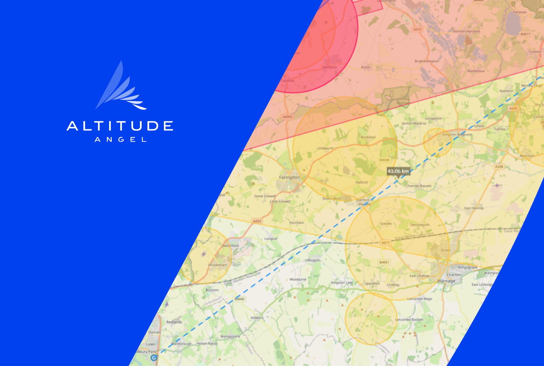
The Flight...
 Image 1: The flight, dronesafetymap.com
So, through what airspace would a drone need to fly through between the two facilities? If we look at image 1 (above) and follow the dotted blue line, taking off from Swindon, the drone will first need to avoid the Sandhill Farm glider site before entering the Area of Intense Aerial Activity (AIAA) which surrounds RAF Brize Norton (to the north, more on that to come)
It would then need to traverse or go around/between two hang-glider sites, Challow Hill Farm and Carswell, after which the drone would have to navigate around or fly through airspace over the Springfield Farm heliport and then over or around the Abingdon airfield.
After either avoiding or going through the Brize Norton Control Zone (CTR) (where permission to fly may need approval), our drone would fly over the city of Oxford before landing at JR.
If we were to replicate the trial taking place in London, we would require the flight corridor to be the subject of a TRA (Temporary Reserved Area). This would mean all other air traffic would be prevented from operating within the airspace, unless permission was sought from those managing the airspace (in the case of the London trial, that means at least 72 hours in advance)
Give me a T. Give me an M. Give me a Z!
Given the large number of other airspace users in this instance, a TRA is not feasible. Put simply, it’s not possible to expect the air ambulance, hang-glider pilots, helicopter pilots, glider operators and the military, plus every other GA pilot who may wish to traverse the airspace, to request permission and to do so at least three days in advance.
So, if not a TRA then maybe a TMZ (Transponder Mandatory Zone). In theory, it’s a wonderful idea. Every airspace user has a transponder on-board helpfully telling the world their location. Drone operators could then see what is in the airspace and plan or execute their flight plan around every user as they can all be seen. Airspace utopia. But here’s the rub. First off, you need 100% co-operation, so every aircraft needs to be broadcasting. Would the RAF or US Air Force be happy to do this? No. And what about the Police? They don’t always want to broadcast where they are for obvious reasons. And then there are Royal flights or those of the Prime Minister...
And secondly, what about the pilot who has no idea there’s a TMZ in place and just comes barrelling through without a transponder? It would be naive to think just because a TMZ is in place everyone knows about it. Furthermore, a non-transponding pilot may know about the TMZ, wish to avoid it, but still stray into the TMZ by accident.
EC is brilliant, the more we can see the greater the chance of avoidance. But it’s not a solution in and of itself.
So, what is the solution?
At Altitude Angel we believe we have the answer. ARROW. ARROW is a ground-based DAA (Detect And Avoid) platform which removes the need for visual observers. It brings together a multitude of sensors, both passive & active, and cameras, ‘fusing’ those data feeds (through our GuardianUTM platform) with airspace data from official and authorised sources, to provide a single-source point-of-truth – a view of the sky which includes both conspicuous and non-conspicuous aircraft. We can see everything, whether it’s saying ‘hello, I’m here!!’ or being flown by Secret Squirrel.
Using the above flight between two hospitals as an example, by spacing our ARROW towers along the flight path, we would be able to enable a drone to be flown between the two hospitals, digitally gain any necessary permissions to fly through restricted airspace, and alert the operator(s) of other airspace users, all without the need for the airspace to be changed or existing airspace users to have or instal any other equipage.
ARROW does the detecting on the drone operator’s behalf.
Altitude Angel is currently going through the CNS (Communication Navigation Surveillance) certification process with the Civil Aviation Authority (CAA). When this is concluded it will be mean operators who have an appropriate ORA (Operational Risk Assessment) will be able to use ARROW as mitigation for the ‘detect’ part of a BVLOS flights.
It is this technology which can, and will, enable true BVLOS flight for all. And we’re ready to deploy it. Are you ready to fly?
ENDS
For more information, please contact:
Stephen Farmer, Head of Corporate Communications & PR, Altitude Angel
stephen@altitudeangel.com
About Altitude Angel
Altitude Angel is an multi award-winning provider of Unified Traffic Management (UTM) software, enabling those operating or developing UTM/U-Space solutions to quickly integrate robust data and services with minimum effort.
Today, Altitude Angel’s market-defining technology is providing a critical enabling service on which the future of UTM will be built across the globe.
Altitude Angel also led a consortium of businesses to build and develop a ‘drone superhighway’ connecting airspace above Reading, Oxford, Coventry, and Rugby. The SKYWAY superhighway network, enabled using Altitude Angel’s patented Arrow® technology, demonstrated the huge potential offered by unmanned aerial vehicles and be a catalyst to enable growth in the urban air mobility industry.
Altitude Angel’s first party solutions also power some of the world’s leading air navigation service providers (ANSPs), aviation authorities and enterprises, including NATS (Services) Ltd in the UK, LVNL in the Netherlands and Avinor in Norway, empowering them with new capabilities to safely manage and integrate drone traffic into national operations.
By unlocking the potential of drones and helping national aviation authorities, ANSPs, developers and enterprise organisations, Altitude Angel is establishing new services to support the growth in the drone industry.
Altitude Angel was founded by Richard Parker in 2014 and is headquartered in Reading, UK.

Related News...
Altitude Angel On Air #7: The one where we talk about Project Skyway
Posted by Altitude Angel Insight
10 Years and an optimistic future
Posted by Altitude Angel Insight
10 years of regulations in the drone industry
Posted by Altitude Angel Insight