 GoDrone will be rolled out with several enhancements for drone pilots across the Netherlands
Netherlands favourite flight planning app to relaunch with enhanced user experience and industry-ready flight planning tool set.
London, UK & Geneva, Switzerland: Netherlands ANSP LVNL and Altitude Angel, the world’s most trusted UTM (Unified Traffic Management) technology provider, have chosen the second day of Airspace World to announce the release of a new and improved version of the popular flight planning tool, GoDrone, bringing a host of new features which will give users an even greater understanding of the country’s airspace and access to it.
Since its launch in April 2020, GoDrone has established itself as the flight planning app for professional and recreational drone pilots across the Netherlands.
“Planning is central to all commercial drone operations within a civil CTR, and any operator should start their flight plan with GoDrone, which is why we’re continuing to invest in the app,” said Wouter Pekela, Program Manager Unmanned Aviation, LVNL.
The new version of GoDrone, which begins rolling out in Q2 for both iOS and Android, is the most extensive update since the app was first launched and includes several enhancements and exciting new features.
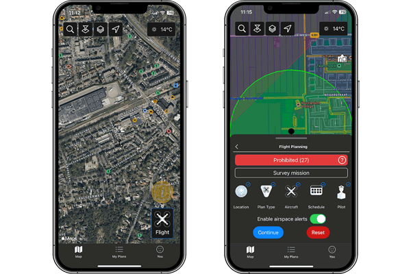 Example images of flight planning in GoDrone 2.0
The suite of updated features includes enhanced integrated flight planning, advanced flight plan drawing tools, and approval services – the ability to request access to fly digitally in airspace such as an airport CTR– through the app.
These updates make the app more user-friendly and intuitive for novice pilots, whilst providing several business-critical services for more experienced and professional operators.
In addition to enhanced integrated flight planning & drawing tools, GoDrone also includes new ‘pilot profiles’ and aircraft management, which provides users with the ability to log drone operator profiles, hours flown, and airframe hours used. These features are particularly useful for professional drone operators who may be required to manage or evidence their operational experience and help in managing airframe service intervals and the like.
Other upgrades and new features also include:
-
New UXUI – Completely rebuilt modern user interface.
-
New Accepted and Approved statuses, allowing GoDrone users to be able to receive more digital updates and information on their mission requests.
-
New Map Types including Satellite Maps to help you plan your drone flights safely and efficiently.
-
Advanced filter setup allows you to fully customise your airspace to suit your preferences, including political border and NOTAM’s.
-
Airframe Hangar – Users will have the ability to input and save all of their drones directly in the GoDrone APP.
-
GoDrone Operator Portal Integration – Information, edits and missions are natively linked between the GoDrone APP and Operator Portal.
-
Ground Hazards – Understand ground hazards in greater details. The Godrone APP now displays a list of ground hazards in the pre-flight report, each clickable providing users with more detailed information.
-
New Area reports feature which gives you a simple-to-understand view of where you can fly safely, where you need to exercise caution or areas that are prohibited.
-
Enhanced Security (Biometrics) utilise the latest security features on your phone or tablet, including eye and fingerprint access.
-
New flight plan tools – Maximise your flight planning by using advanced drawing tools, or upload files directly from your device.
ENDS
For more information, please contact:
Stephen Farmer, Altitude Angel, Head of Corporate Communications & PR
stephen@altitudeangel.com.
About Altitude Angel
Altitude Angel is an award-winning provider of UTM (Unified Traffic Management) software, enabling those planning to operate, or develop UTM/U-Space solutions, to quickly integrate robust data and services with minimum effort. Its technologies include Common Information Service (CIS) UTM Service Provider (USSP) and UTM Supplemental Data Services Provider (SDSP) capabilities, combined on a central platform which is connected to hundreds of thousands of drone pilots worldwide.
Today, Altitude Angel’s market-defining technology is providing a critical, enabling service on which the future of UTM will be built across the globe. Altitude Angel is leading a consortium of businesses to build and develop 165 miles (265km) of ‘drone superhighways’ connecting airspace above Reading, Oxford, Milton Keynes, Cambridge, Coventry, and Rugby over the next two years. The Skyway superhighway network, enabled using Altitude Angel’s patented ARROW technology, will unlock the huge potential offered by unmanned aerial vehicles and be a catalyst to enable growth in the urban air mobility industry.
Altitude Angel’s first party solutions also power some of the world’s leading ANSPs, aviation authorities and Enterprises, including LVNL (Netherlands) and Avinor (Norway), empowering them with new capabilities to safely manage and integrate drone traffic into national operations.
By unlocking the potential of drones and helping national aviation authorities, ANSPs, developers and enterprise organisations, Altitude Angel is establishing new services to support the growth in the drone industry.
Altitude Angel was founded by Richard Parker in 2014 and is headquartered in Reading, UK.
Altitude Angel’s developer platform is open and available to all at https://developers.altitudeangel.com
Share this article:

Related News...
North Weald Airfield enhances visibility & safety with GuardianUTM
Posted by Altitude Angel Announcement
Altitude Angel awarded U.S. Patent for groundbreaking ARROW technology
Posted by Altitude Angel Announcement
Approval Services platform to launch at Marina de Lagos, Portugal
Posted by Altitude Angel Announcement